Water
Deepen your insight into this critical resource
Water
Flowing forward with location intelligence
The challenges of the water industry have become a strategic issue. With concerns including infrastructure, climate change and regulatory compliance, location intelligence is a powerful tool which can help address industry challenges.

Address the deepest challenges
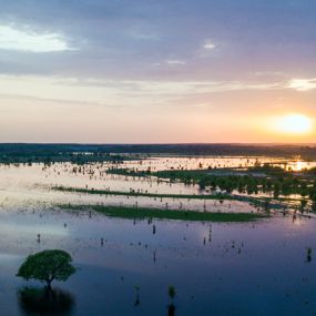
The UK water industry faces significant challenges, impacting both supply and infrastructure. Climate change is now one the most important factors affecting water availability and quality, both directly and indirectly. While ensuring compliance with regulatory and environmental constraints, upgrading the aging infrastructure requires substantial investment.
Location intelligence offers numerous benefits to the water industry by enhancing spatial analysis, asset management and decision-making.
Intelligent management
Location intelligence can provide the water industry with a robust framework for spatial analysis, data integration and real-time monitoring. Precise mapping of water infrastructure (pipes, pumps, treatment plants and reservoirs) enables efficient asset management.
The use of detailed asset inventory management enables predictive maintenance, reducing the likelihood of failures and extending the lifespan of assets.
In resource management, location intelligence facilitates the analysis of water distribution and consumption patterns. By integrating environmental data it can help manage water resources sustainably.


Monitor environmental impact
Monitoring environmental impact is an important responsibility of water companies. Irregularity of weather patterns and pollutant discharge from industrial / agricultural operations contribute to the need for precision monitoring of this vital resource.
Location intelligence allows for the integration and analysis of spatial data related to environmental factors. Visualisation and analysis of these data layers allows assessment and understanding of the impact of human activities and natural processes on water resources.
Improve engagement
Location intelligence enhances stakeholder engagement across the water industry by providing spatially explicit information and interactive communication.
Interactive mapping and data visualisation support stakeholder and community engagement. By creating maps that overlay project plans, environmental features and community demographics, stakeholders can grasp the geographic context and potential outcomes of proposed initiatives.
This will allow the exploration of alternative scenarios, assess trade-offs and visualise impact in real-time.

Location intelligence solutions for water

UK Map Data
We carry only the very best data available for our home nation, including products from trusted sources such as Ordnance Survey, Ordnance Survey Northern Ireland and Bluesky International. Let us help make your UK-based location intelligence solution exceed expectations and deliver eminent success.
Risks & Perils
A portfolio of geo-referenced risks & perils data with models for events including flood, subsidence, political risk and climate change. Serving more than just insurers, these products help you evaluate risk to property and assets, improve readiness and bolster your ability to respond and mitigate.

viaEuropa
viaEuropa is the award-winning hosted map and API platform from Europa Technologies. It delivers high quality, fully maintained, digital maps and geodata directly to your web applications, desktop GIS and mobile apps. Use viaEuropa to drive location intelligent solutions quickly, easily and efficiently.
viaEuropa supports a variety of high-quality content from Ordnance Survey, Ordnance Survey Northern Ireland, Bluesky International, Government of Jersey, JBA Risk Management, British Geological Survey, MB International and OceanWise.

Location Insight
Location Insight offers a powerful yet intuitive means of visualising and analysing spatial data. Designed to provide a simple way to understand sophisticated spatial analytics, it allows organisations to better understand their customers, assets and markets, in a geographic context, thereby gaining a competitive or strategic advantage. Implemented as an online service, Location Insight can be integrated into your internal systems to provide a rich, seamless experience for your users.
How can we help you?
Do get in touch if you would like more details about Water (technical, licensing, pricing, etc.) or would like to arrange a personalised demo. Our product specialists will be happy to provide you with a free consultation.

